Drone Construction Progress Monitoring in Pune
Real-time aerial documentation, orthomosaic mapping, and timelapse reporting for active construction sites across Pune and Maharashtra. DGCA-licensed, ISO-registered, pay only after delivery.
Overview
AerialPhotoIndia is a leading drone services company in Pune , delivering drone-based construction progress monitoring across Pune and Maharashtra. We capture real-time, high-resolution aerial imagery and timelapse video documentation so developers, contractors, and consultants can verify site conditions without leaving their desk.
Explore our full portfolio of drone services — from aerial photography to facade inspection, surveying, and 360 virtual tours — built around a single promise: pay only after the problem is solved.
Trusted by Leading Developers
A small sample of construction and infrastructure clients who have engaged AerialPhotoIndia for drone progress monitoring and aerial documentation.
Benefits of Drone Monitoring
Replace partial site walks and dated photos with verifiable, geotagged aerial documentation that everyone on the project can trust.
Real-time progress
Geotagged aerial captures on your schedule — daily, weekly, or monthly — keep every stakeholder aligned on what is actually built.
High-resolution data
4K aerial photos, orthomosaic maps, and 3D visualisations at centimetre-level accuracy for measurement and verification.
Custom dashboards
Automated reports and dashboards consolidate captures, measurements, and progress notes into a single source of truth.
Early issue detection
Anomalies in site layout, encroachments, or works-out-of-sequence are flagged before they become rework.
Software integration
Outputs are delivered in formats compatible with AutoCAD, GIS platforms, and common project management tools.
Reduced delays and rework
Independent aerial verification at each milestone keeps schedules honest and dispute costs low.
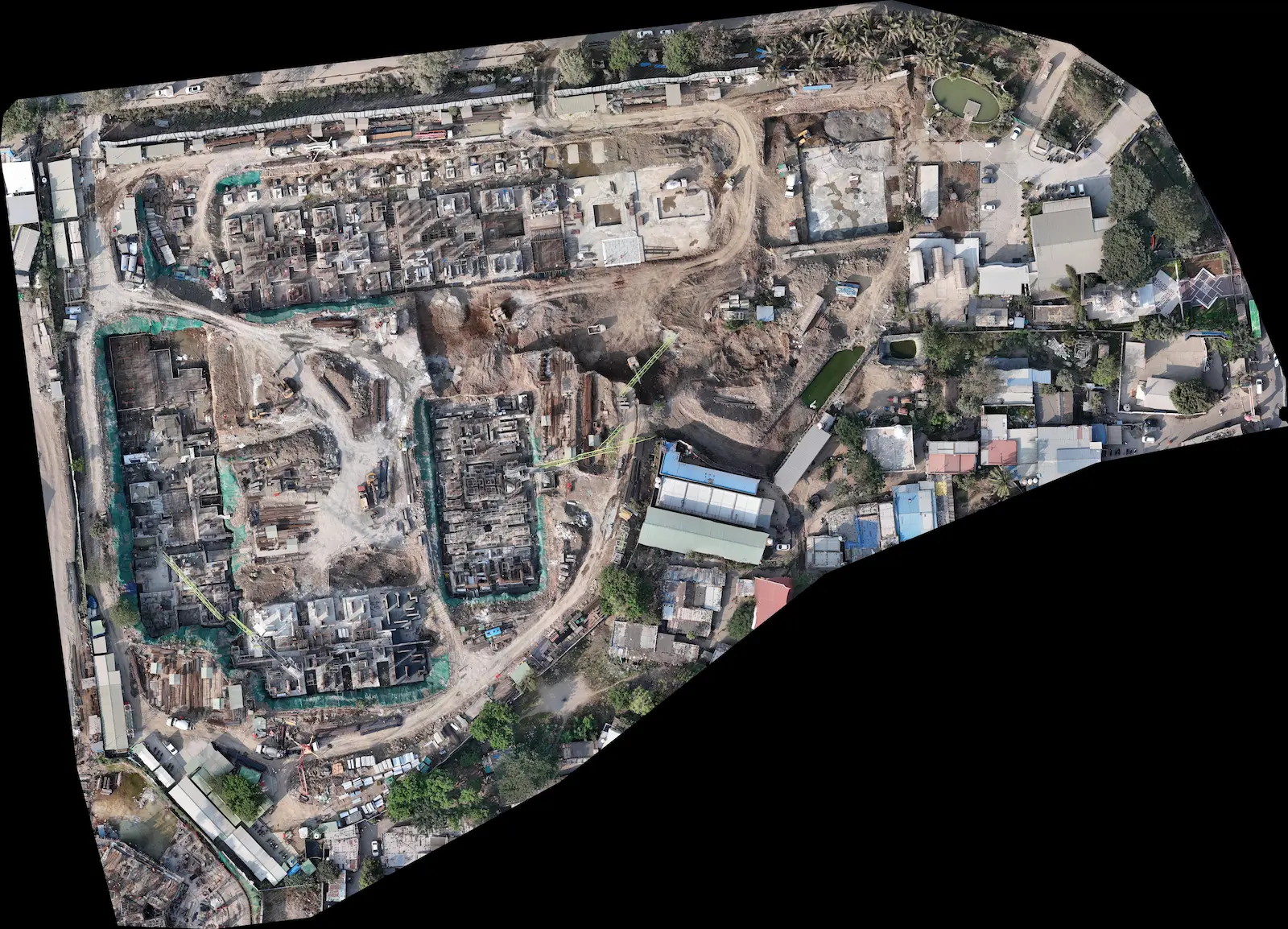
Aerial Documentation in Action
A representative orthomosaic and progress capture from an AerialPhotoIndia construction monitoring engagement in Pune.
Key Features & Inspection Capabilities
Construction monitoring engagements at AerialPhotoIndia bundle aerial documentation with optional inspection add-ons, so you can replace several specialist visits with a single drone mobilisation.
Orthomosaic mapping
Geotagged orthomosaic maps of the entire site with measurement overlays, exportable for AutoCAD and GIS workflows.
Timelapse documentation
Aerial timelapse video covering the full build cycle — fixed frame, fixed altitude, identical headings across captures.
Rooftop & facade inspection
Rooftop and façade thermal drone inspection with visual sensors to detect water ingress, insulation defects, and finishing anomalies.
360° virtual tours
Aerial and ground 360° captures for stakeholder walkthroughs ( view demo ).
Lifecycle documentation
Long-term capture archives from groundbreaking to handover, indexed by date and milestone for audit and marketing use.
Measurement & volumetrics
Earthwork volumes, stockpile measurements, distance and area calculations from drone-derived 3D models.
Transparent Pricing. Pay After Delivery.
AerialPhotoIndia engagements are priced per site and per capture cycle, with no upfront deposit. You only pay once deliverables are accepted — our standing commitment across every service except thermography retainers. See our drone services pricing in Pune for starting rates across all services.
Quote turnaround
Scoped pricing returned within one working day of enquiry.
Advance payment
No deposit required to begin. Pay only after delivery.
Licensed & insured
Operations covered by DGCA license and commercial third-party insurance.
Track record
Operating since 2010 with 300+ clients and 500+ delivered projects.
Construction Monitoring Showreel
A short showreel of recent drone construction monitoring engagements across Pune and Maharashtra.
Frequently Asked Questions
How does drone-based construction progress monitoring work?
AerialPhotoIndia operates DGCA-licensed UAVs that capture geotagged aerial imagery, orthomosaic maps, and timelapse video over your construction site. Captures can be scheduled daily, weekly, or monthly depending on project pace, and outputs are delivered as high-resolution images, 3D models, and progress dashboards.
Which cities and regions do you cover for construction monitoring?
Our base of operations is Pune. We deliver drone construction monitoring across Pune, PCMC, Mumbai, and the wider Maharashtra region. Pan-India deployments are arranged for multi-site developers on request.
What deliverables are included with a construction monitoring engagement?
Standard deliverables include geotagged 4K aerial photos, drone videos, monthly orthomosaic maps with measurement overlays, timelapse compilations, and a written progress report. Optional add-ons include 360 virtual tours, 3D models, and thermal inspections.
Is there an advance payment required?
No. AerialPhotoIndia operates on a pay-after-delivery model for construction monitoring engagements. You only pay once the agreed deliverables are provided and accepted, giving you complete confidence before any commitment.
How quickly can you start a construction monitoring engagement?
Quotes are returned within 24 hours of enquiry. For Pune-based projects, on-site capture can typically be scheduled within 3 to 5 working days, subject to site access, DGCA airspace clearances, and weather.
Are you licensed and insured to operate drones over active construction sites?
Yes. AerialPhotoIndia is DGCA-licensed, ISO-registered, MSME and GSTIN registered, with comprehensive third-party liability insurance for drone operations over commercial and construction sites.
Get a Free Quote
Whether you are a developer, contractor, or consultant, our team will scope your construction monitoring requirement and return a quote within 24 hours. No advance payment required.
Address
NH4, opposite Navale Hospital, Helicam, Pune, Maharashtra 411041, India