Professional
Drone Services
in Pune

ISO-registered and DGCA compliant since 2010 — AerialPhotoIndia delivers aerial photography, industrial inspections, drone survey, thermal imaging, and 360° virtual tours to construction companies, infrastructure firms, and factories across Pune and Pimpri-Chinchwad.

ISO Registered MSME Certified DGCA Compliant GST Registered Since 2010
Our Services Drone Photography Aerial Photography Facade Inspection Drone Survey Thermal Inspection 360 Virtual Tours Pilot Training

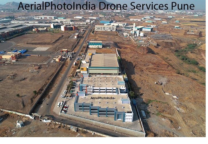
Pune's construction sector, manufacturing belt, and infrastructure corridors have driven demand for professional drone services that go beyond photography — operators who understand site safety, DGCA permit requirements, data accuracy, and project timelines. Since 2010, AerialPhotoIndia has been the drone services partner of choice for construction companies in Wakad, power infrastructure projects in Moshi, factories across Chakan and Talegaon, and IT campuses in Hinjewadi — delivering aerial data that decision-makers can actually use.

This page covers the full range of drone services available in Pune, the equipment used, areas served, and what to look for when selecting a provider for your project.

Areas Served Across Pune & PCMC

AerialPhotoIndia operates across the full Pune Metropolitan Region, including Pimpri-Chinchwad Municipal Corporation (PCMC) and surrounding industrial zones. Most Pune projects are mobilised within 24 hours.

Hinjewadi
Baner
Hadapsar
Pimpri-Chinchwad
Chakan
Talegaon
Wakad
Moshi
Kharadi
Viman Nagar
Bhosari
Pune Cantonment

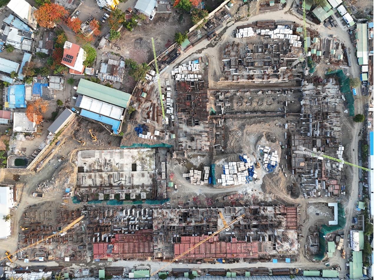
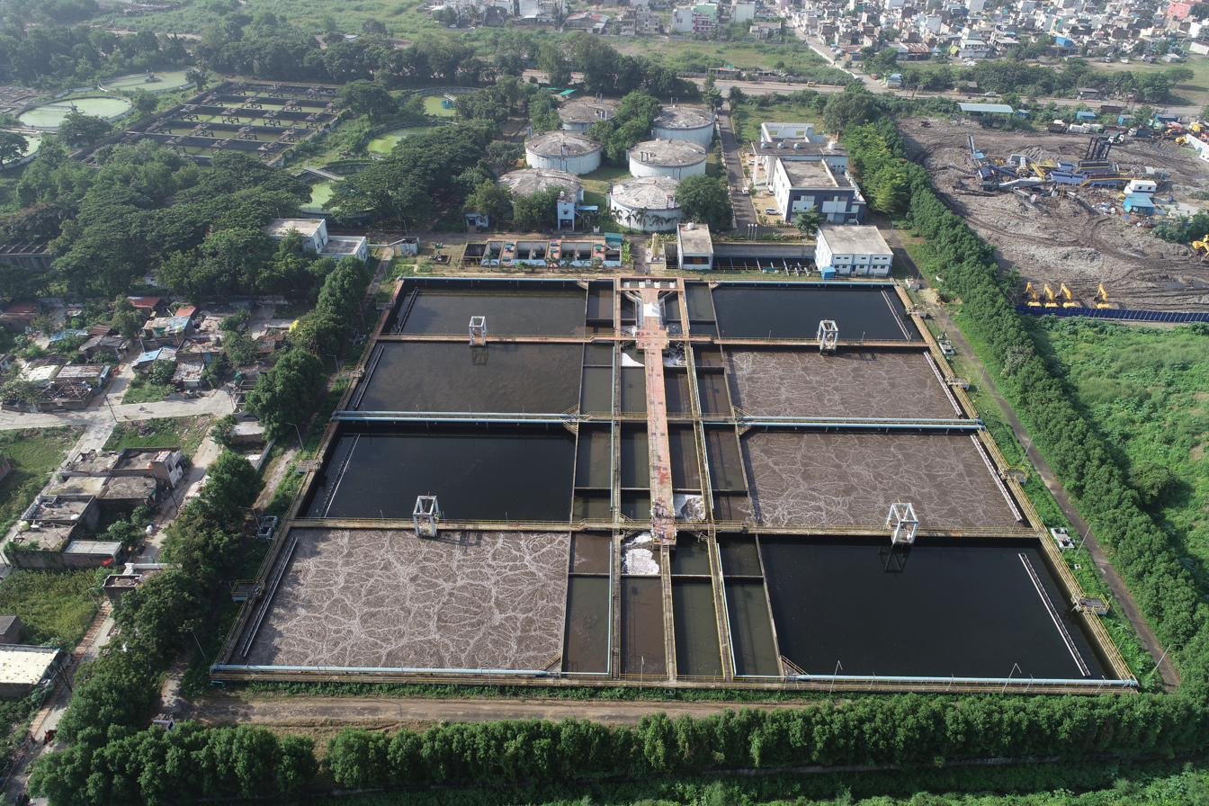
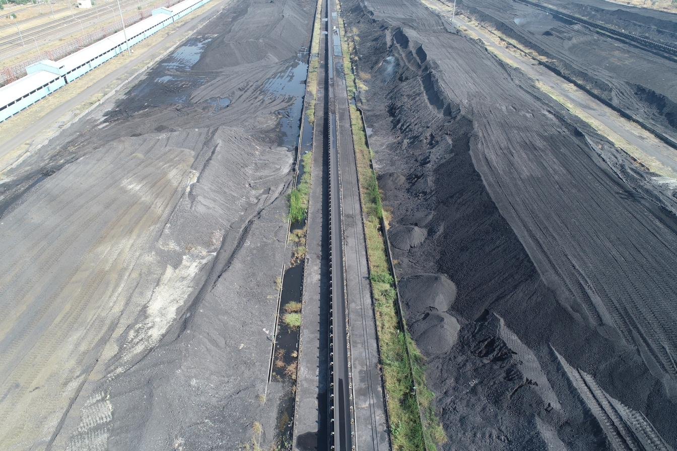
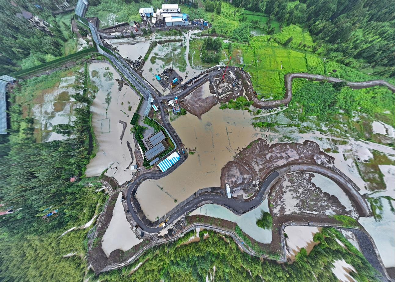
Project Experience in Pune

Two examples from our active project portfolio in the Pune region:

Case Study · Residential
Construction Progress Monitoring — Wakad
18 Months Residential Tower Pune
Aerial documentation of a multi-storey residential development in Wakad across an 18-month construction cycle. Deliverables included monthly timestamped orthomosaic maps, site progress video reels for investor reporting, and top-down stills for project management dashboards.
Case Study · Infrastructure
Power Plant Construction Monitoring — Moshi
24 Months Power Infrastructure PCMC
Long-form aerial documentation of a power plant construction project in Moshi across a 24-month build phase. Provided fortnightly aerial surveys with geo-referenced progress overlays, enabling the project team to track civil works, equipment placement, and site logistics from a single aerial record.

Equipment & Technical Capabilities

The quality of drone deliverables depends entirely on the equipment used. AerialPhotoIndia operates professional-grade systems purpose-built for commercial and industrial work.

📷
100MP Imaging Drone
Used for aerial photography, real estate marketing, construction documentation, and videography. 100-megapixel resolution delivers print-quality imagery suitable for large-format output, detailed inspection, and high-resolution project archives.
📡
RTK Survey Drone
Real-Time Kinematic (RTK) positioning delivers centimetre-level GPS accuracy without the need for ground control points. Used for orthomosaic mapping, digital elevation models (DEMs), topographic surveys, contour mapping, and volumetric calculations.

All flights are conducted in compliance with DGCA regulations, with necessary permissions obtained before every operation. We carry liability insurance and maintain complete flight logs for all commercial engagements.

Construction Progress Monitoring

Construction companies in Pune — from residential developers in Wakad to infrastructure contractors in Chakan — use drone-based construction monitoring to maintain accurate, timestamped records of site progress without relying on ground photography or manual site visits from stakeholders.

Overhead drone photograph documenting construction progress of large residential development in Pune — AerialPhotoIndia
Construction Progress Monitoring — Top-Down View · Residential Development, Pune
Timestamped Records
Every flight produces geo-tagged, dated imagery that creates an unambiguous audit trail of construction milestones for investors and approvals.
Stakeholder Reporting
Aerial progress reels and orthomosaic overlays give investors and project heads a clear picture without requiring site visits.
Issue Detection
High-resolution top-down imagery reveals discrepancies between approved plans and actual site work before they escalate.
Long-Term Contracts
We support 12 to 36-month monitoring contracts with regular scheduled flights and consistent deliverable formats throughout.

Industrial & Facade Inspection Services

Factories in the Chakan and Talegaon industrial belts, infrastructure plants in Moshi and Bhosari, and commercial structures in Hadapsar and Hinjewadi all require periodic inspection of structures that are difficult or dangerous to access using traditional methods. Professional drone facade inspection eliminates the cost and risk of scaffolding and rope access.

Aerial drone inspection of large industrial facility — AerialPhotoIndia industrial drone services Pune PCMC
Industrial Facility Aerial Inspection · Pimpri-Chinchwad Industrial Area
  • Factory Roof & Cladding Inspections
  • Chimney & Stack Assessments
  • Solar Plant Thermal Inspections
  • Telecom Tower Surveys
  • Power Infrastructure Monitoring
  • Residential Society Building Inspections

For thermal defect detection — hotspots in solar panels, moisture ingress in building facades, insulation failures in industrial roofs — we combine visual imaging with thermal drone inspection for a complete picture in a single mobilisation.

Drone Survey & Photogrammetry for Infrastructure Projects

Infrastructure and civil engineering projects across Pune's rapidly expanding urban fringe — from Talegaon township developments to Chakan industrial parks — require accurate geospatial data at scale. RTK drone surveys deliver this data faster and more accurately than conventional ground methods.

Digital Elevation Model generated from RTK drone photogrammetry survey — AerialPhotoIndia Pune
Digital Elevation Model (DEM)
9cm resolution orthomosaic map produced by RTK drone mapping survey — AerialPhotoIndia
9cm Resolution Orthomosaic Map

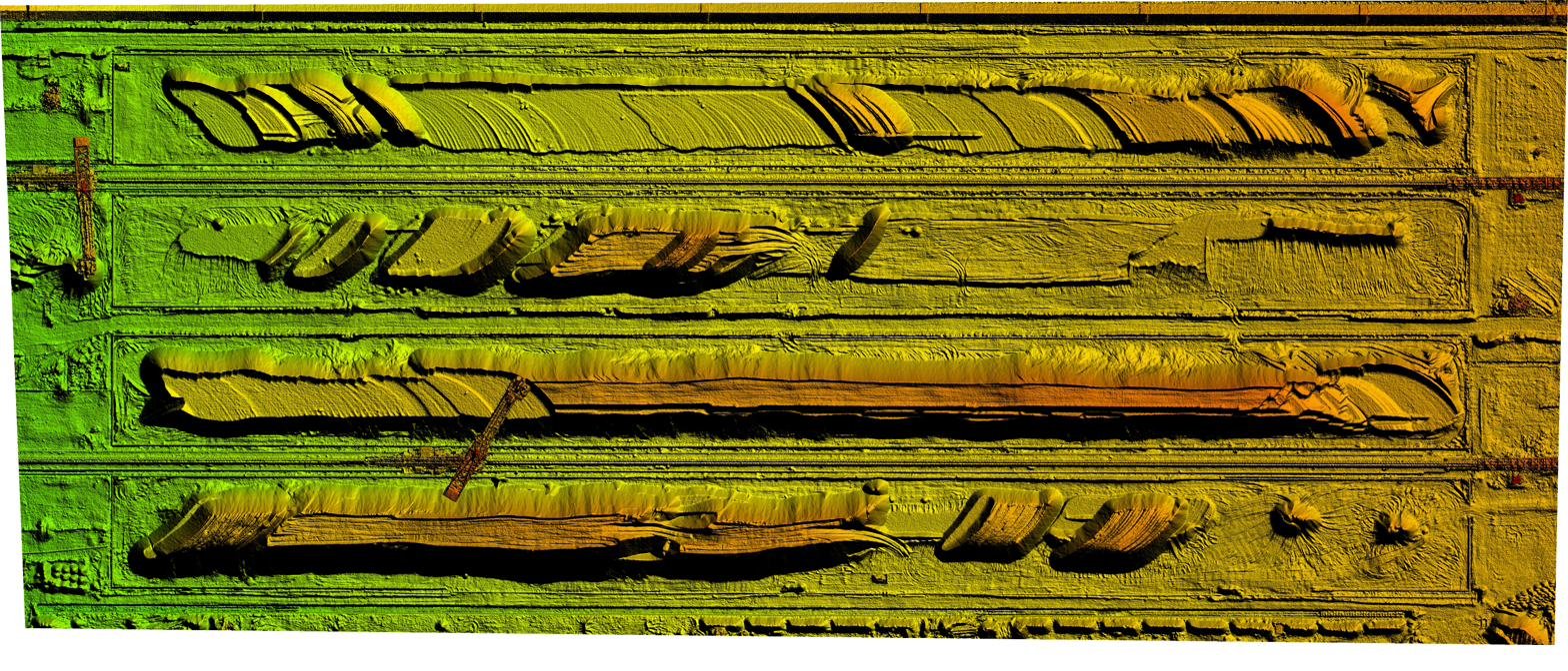
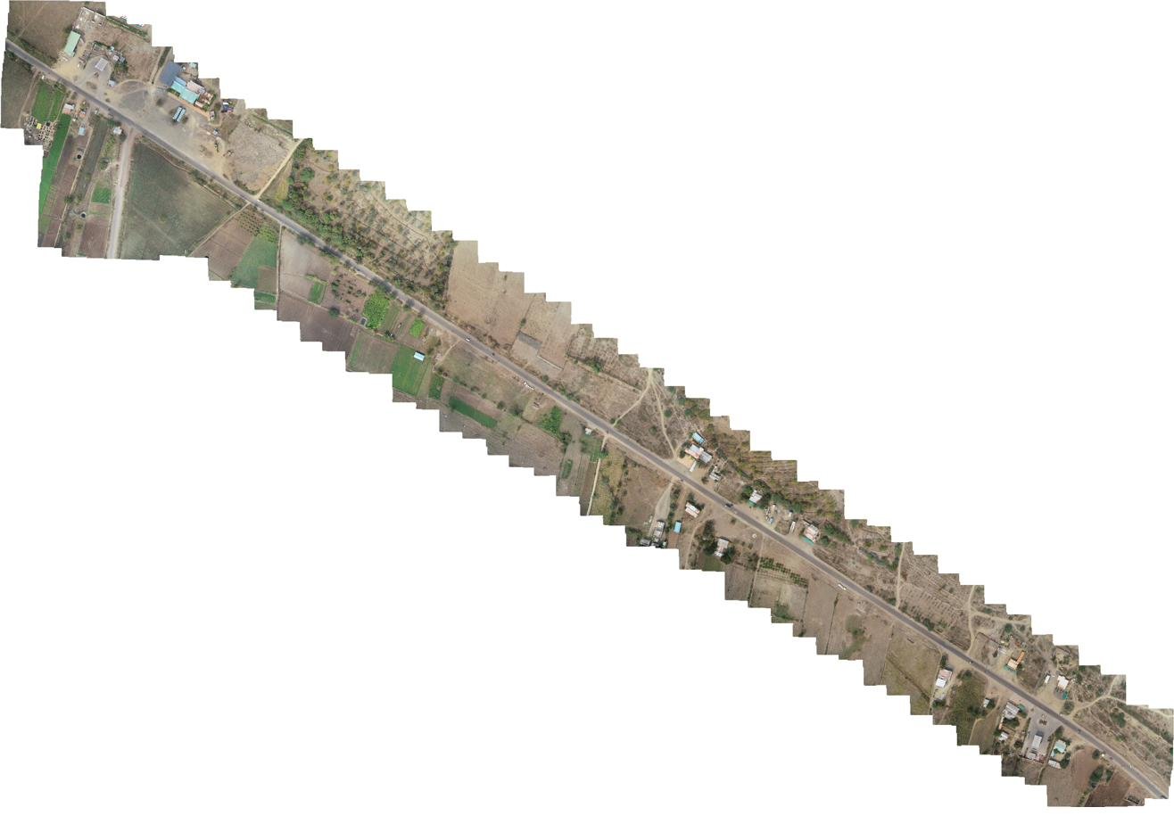
Our RTK drone delivers centimetre-level positional accuracy. Typical survey deliverables include:

  • Orthomosaic Maps (up to 9cm GSD)
  • Digital Elevation Models
  • 3D Terrain & Surface Models
  • Topographic Contour Maps
  • Volumetric Stockpile Calculations
  • AutoCAD-compatible Outputs
Drone-based volumetric stockpile calculation at industrial facility — AerialPhotoIndia survey services Pune
Volumetric Stockpile Calculations · Industrial Facility, Pune Region

Aerial Photography & Drone Videography

The 100MP imaging drone produces aerial photographs with enough resolution to zoom into fine architectural detail at full print quality — well beyond what most projects require, but the headroom matters when clients need to crop, enlarge, or repurpose imagery across multiple formats. Real estate developers in Baner and Hadapsar, IT campus developers in Hinjewadi, and resort properties near Pune use this capability for marketing, branding, and sales collateral.

100MP bird's eye view aerial photograph of development site — AerialPhotoIndia drone photography Pune
100MP Aerial Photography · Development Site, Pune
Real Estate & Development
Showcase layouts, infrastructure proximity, and project scale with imagery that communicates what no ground photo can.
Industrial & Campus
Document factory campuses, IT parks, and logistics hubs for corporate communications, annual reports, and safety audits.
Cinematic Videography
Smooth aerial video content for project launches, investor presentations, social media, and brand films.
360° Virtual Tours
Immersive aerial panoramas and virtual tours for real estate sales, industrial showcases, and tourism projects.

Watch Our Drone Portfolio

AerialPhotoIndia drone services portfolio — aerial photography and videography across Pune and Maharashtra Drone Services Portfolio — AerialPhotoIndia

Certifications & Compliance

Operating commercially with drones in India requires more than owning equipment. DGCA certification, insurance, and formal business registration are non-negotiable for industrial clients, government infrastructure projects, and any work near controlled airspace. AerialPhotoIndia has held all required certifications since well before DGCA regulations were formalised.

🏛️
ISO Registered Quality management certified
🏢
MSME Certified Ministry of MSME, Govt. of India
✈️
DGCA Compliant Drone operator certification
📋
GST Registered Formal tax-compliant business entity

All commercial engagements come with proper invoicing, GST-compliant billing, and flight documentation — a requirement for institutional clients, real estate developers, and infrastructure firms managing project accounts.

What to Look for in a Pune Drone Services Provider

With more operators entering the market, knowing how to evaluate a drone services company in Pune saves time and avoids costly mistakes. These are the criteria that matter for commercial and industrial engagements:

AerialPhotoIndia meets all of these criteria and has done so since 2010 — before most current operators were active in the Pune market.

Frequently Asked Questions

Which areas of Pune do you provide drone services in?
AerialPhotoIndia provides drone services across all major areas of Pune including Hinjewadi, Baner, Hadapsar, Pimpri-Chinchwad, Chakan, Talegaon, Wakad, Moshi, and the Pune Cantonment area. We also cover Mumbai and all of Maharashtra. Most Pune-region projects can be mobilised within 24 hours of booking confirmation.
What industries do you primarily serve in Pune?
Our primary clients in Pune are construction companies, infrastructure firms, and manufacturing factories. We have active long-term construction monitoring engagements, ongoing industrial inspection contracts, and regular aerial photography projects for real estate developers across the Pune Metropolitan Region.
What drone equipment does AerialPhotoIndia use?
AerialPhotoIndia uses a 100MP imaging drone for aerial photography and videography, and RTK-enabled drones for precision survey and mapping work. RTK (Real-Time Kinematic) positioning delivers centimetre-level accuracy for orthomosaic maps, digital elevation models, and volumetric calculations — without requiring physical ground control points on site.
Is AerialPhotoIndia DGCA certified and legally compliant?
Yes. AerialPhotoIndia holds ISO registration, MSME certification, DGCA drone operator certification, and GST registration. We have been operating commercially and legally since 2010. All commercial flights are conducted under DGCA-compliant operating procedures with full flight documentation and liability insurance coverage.
Do you handle long-term construction monitoring contracts?
Yes — long-term monitoring is one of our core services. We have completed projects including 18-month construction monitoring of a residential tower in Wakad and 24-month monitoring of a power plant construction project in Moshi, PCMC. We support 12 to 36-month contracts with scheduled flights, consistent deliverable formats, and project reporting tailored to stakeholder requirements.

Get a Quote for Drone Services in Pune

Whether you need a one-time aerial survey, regular construction monitoring, an industrial inspection, or a full aerial photography package — AerialPhotoIndia has the equipment, certifications, and project experience to deliver. We serve construction sites, factories, and infrastructure projects across Hinjewadi, Baner, Hadapsar, Pimpri-Chinchwad, Chakan, Talegaon, and the broader Pune Metropolitan Region.

Call +91 93710 44204 or use the form below to discuss your project requirements.

Request a Quote Explore All Services